
Innovative map of the Tatra Mounatins voted the best by Journal of Maps
The Tatra Mountains during the Last Glacial Maximum, a map created by Dr inż Jerzy Zasadni from the AGH University of Science and Technology Faculty of Geology, Geophysics and Environmental Protection and Dr Piotr Kłapyta from the JU Institute of Geography and Spatial Management, was voted the best map of 2014 by the Journal of Maps international magazine.
Journal of Maps is the only magazine which publishes electronic versions of maps illustrating the results of research from various academic fields. Every year, the committee evaluates nearly over 70 research papers. Out of eleven papers which qualified into the finals, the Polish one was voted the best.
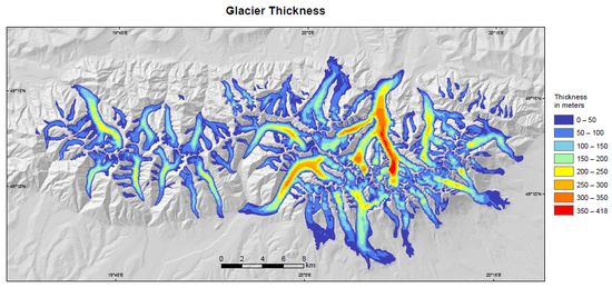
The map illustrates the topography of the Tatra Mountains during the last glacial maximum (over 20,000 years ago). It is the first map to provide a three dimensional model of glaciers in the entire mountain range on the basis of numerical models of the terrain. The details visible on the surface of the glaciers reflect their probable topography. Thanks to its form, the map will surely prove to be a wonderful in popularising knowledge about climate change and promoting Poland and its environment. It will be printed out in a limited edition (200 copies) and available for purchase.
The map of the Tatra Mountains during the Last Glacial Maximum 1:50,000
Dr Jerzy Zasadni and Mgr inż. Andrzej Świąder from the AGH University of Technology have prepared an aerial view animation based on the data from the map.
Published by: Łukasz Wspaniały
Uniwersytet Jagielloński